


Collaring in OAM
07 Dec 2007Collaring can pre-exist in images that have been masked prior to delivery, or can be generated by the process of re-projection, as the spare pixels in the target system get filled in with “no data” values.
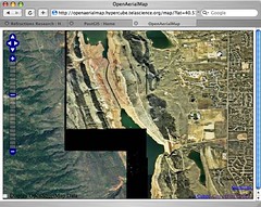
Sean uploaded some data from his home town of Fort Collins, and the OAM process to reproject it into the global OAM scheme (lat/lon?) collared it, which shows up at the edges of the data.
There are some GDAL tricks to make the collars transparent, but if there’s some blank “no data” areas in the source imagery, it is hard to avoid it. OSSIM has some more advanced mosaicking capabilities that might fit the OAM processing needs better than GDAL.