


On Guard
11 Nov 2008
While the “Obama-dot” in Charlie Savage’s rally snapshot is nice:

What really makes the picture, to my mind, is the snipers on the roof:

Nothing says democracy quite like snipers! :)
11 Nov 2008
While the “Obama-dot” in Charlie Savage’s rally snapshot is nice:
What really makes the picture, to my mind, is the snipers on the roof:
Nothing says democracy quite like snipers! :)
05 Nov 2008
I’ve always been a bit of a connoisseur of election maps, but most maps don’t really tell me much that I don’t already know. The maps I like best are those that show smaller geographies than usually reported (in Canada, maps of polls instead of ridings, in the USA, maps of counties instead of states) and those that show changes from previous results – “delta maps”. The New York Times is currently running one on their front page, here’s a snapshot.
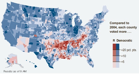
The colors are not reflective of number of votes, but of direction of movement. Hence, Montana colored blue even though McCain won it, because in every county Obama did better than Kerry did in 2004.
One of the things I found curious about the numbers in the paper today is that while Obama won a strong Electoral College victory, his popular vote share is not much different from the share Bush won in 2004, and Bush won a squeaker in the Electoral College. The map tells the tale.
McCain didn’t lose support across the board, he actually improved on Bush in places, but mostly in places where the Republicans were already winning smashing majorities – more votes in Alabama don’t get you any closer to the Presidency. So a respectable showing in the popular vote translates into an Electoral College whomping.
Somewhat disturbing is how nicely the red areas map into the phrase “rural white voters in former slave states”. History just never goes away, does it?
03 Nov 2008
Most commit messages are pretty terse affairs (“Fix for issue #142.”, “Remove compile warnings.”) but this morning, Mark Cave-Ayland posted this novel along with his code changes:
r3224 /trunk/loader/ (Makefile.in pgsql2shp.c wkb.h)
Switch pgsql2shp over to using liblwgeom.
There are few commits that can be as satisfying as one which involves the removal of ~1200 lines of code. By using the liblwgeom parser instead of the in-built parser, we have now achieved the following:
i) all parsers within PostGIS, shp2pgsql and pgsql2shp are now the same which means they all follow the same rules. Also extended error reporting information including error text and position information is available.
ii) the complexity of the shp2pgsql/pgsql2shp is considerably reduced.
The slightly unfortunate cost is the overall executable size is larger, since we are linking with liblwgeom. However, from both a consistency and maintainability point of view, this is a big win. Note that while there may be a difference in behaviour in some corner cases, all regression tests pass here.
Some extra explanation is in order. Mark’s goal for the 1.4 release of PostGIS is to clean up the underlying code and make it easier to develop on. That has resulted in some major reorganization under the covers.
The geometry framework (liblwgeom) under PostGIS was written to be separable from the rest of the specific PgSQL code, but historically was managed right alongside it, in the same directory and built chain. Mark has broken it out into it’s own directory with a separate build out to a true library file.
Now that the geometry framework is a true library, it can be used in other places, not just the back-end. So hooking the data loader/dumpers into it is a first step, and as he notes, improves the code immensely.
31 Oct 2008
I’m working on re-writing the PostGIS driver in Mapserver to clean it up a little and hopefully make it faster, and seeing the flow of control, there are a couple ways users of the existing driver can improve performance with small configuration changes. The simplest syntax for defining a PostGIS layer in Mapserver is just:
DATA "the_geom from the_table"
Very simple, but: how does Mapserver know what primary key to use in queries? And what SRID to use when creating the bounding box selection for drawing maps? The answer is, it asks the database for that information. With two extra queries. Every time it processes the layer.
However, if you are explicit about your unique key and SRID in configuration, Mapserver can, and does, skip querying the back-end for that information.
DATA "the_geom from the_table using unique gid using srid=4326"
Also, if you have more than one PostGIS layer in your map file, you should turn on the Mapserver connection pool, even if you’re not running in FastCGI mode. That’s because the pool will allow all the layers to reuse the same connection. If you have have seven PostGIS layers, at 15ms per connection, that’s 90ms saved (you still pay 15ms for the first connection).
Add this line at the end of each PostGIS layer to tell Mapserver to leave the connection open for future layers:
PROCESSING "CLOSE_CONNECTION=DEFER"
Go fast, fast, fast!
29 Oct 2008
Today my wife went back to work, which means the “new regime” is in effect!
I admit, I’ve been taking it pretty easy the last 18 months, I haven’t cooked a lot of breakfasts or meals. Really, I’ve been a bum.
But mornings now, my wife has to get ready for work, which means I have to feed and water the kids (toss some slops in the bin, hose them down afterwards, you know the drill) and get them ready to be carted off to daycare. Wake up and get that game face on! It’s really very nice, and reminds me of my year at home taking care of my daughter when she was one – dealing with the little details of kid life is very gratifying (in moderate doses).
And the pay-off? Once they head out the house descends into silence, blessed silence. Super-productive morning today.