


Sick, sick, sick
21 Jun 2008
Sean has starting posting early-season vegetable porn… time to head to the back yard to get some pictures of my hotties (oh, hoping for baby fingerling potatoes with aioli tomorrow).
21 Jun 2008
Sean has starting posting early-season vegetable porn… time to head to the back yard to get some pictures of my hotties (oh, hoping for baby fingerling potatoes with aioli tomorrow).
18 Jun 2008
Chris Holmes points to an essay by Muhammad Yunus, which starts from the idea that:
[The entrepreneur] is dedicated to one mission in his business life – to maximize profit.
There’s a quote from a noted philanthropist that pretty much sums up my opinion on this matter:
That’s the stupidest thing I have ever heard.
– Bill Gates
Take, for example, the woman profiled in the New York Times last week, who has been running her start-up bakery at a loss for a year, and is hoping, sometime in the next year, to start paying herself a salary! This woman has been feeding the people of West Acton, Mass. subsidized baked goods for twelve months, working for free, and plans to keep it up – I’m guessing that profit maximization is probably not her primary motivation. I’m guessing that it is, let me see, that she really like baking things?!?
People who haven’t run a business tend to get all worked up about “profit”, but bear in mind that for fortunate businesses profit is 20-30% of revenue, and for most businesses it is less than 10%. That leaves the other 90% of the revenue that has to be tracked down, brought in the door, and worked, just to keep the doors open. Proportionate to the profits earned, most business are basically break-even affairs.
My revised, more accurate, formulation of Yunus’ axiom is that “the entrepreneur is dedicated to one mission in his business life – to cover his costs. Everything after that is gravy.” Most entrepreneurs go home happy knowing they’ve kept the doors open for another day, doing something that they (at least when they started) enjoy.
16 Jun 2008
I’m in Delft, the Netherlands, this week, to present a PostGIS workshop and (more worryingly) give a keynote address at an open source geospatial meeting. As usual, I am wrestling with performance anxiety. I enjoy it when I’m doing it, and I’m happy when I’m done, but gods the anticipation of public speaking drives me crazy.
Anyhow, for other North American travelers, note that, when the Dutch say “stairs”, they mean “ladder”:

When they say “breakfast”, they mean “lunch”:

And when they say “pancake”, they mean “dinner”:

16 Jun 2008
The Thematic Mapping Blog has been on a 3D chloropleth jag lately, exploring all the ways to display global variables on a map of the world. The technical achievements are all very nice, but the actual display of the useful numbers, is as usual totally screwed by the intractable fact that countries are radically different sizes!
The trouble with chloropleth maps, is that you’re trying to display numerical data visually, but one of the most visually arresting features of your display is a variable that you do not care about, the size of the regions.
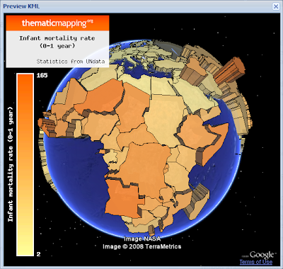
What do I get out of the global map display of world data, that I don’t get out of a simple rank-ordered table? A and B are high, and A and B are on the same continent. That could be done by coloring the rank order table by continent. A and B are high, and A and B are adjacent. That’s harder.
I’ve really become fond of the cartogram approach, as a partial solution to this problem, but it has it’s own problems.

We’re in for a whole slew of this kind of stuff, with the US election offing, since the Republicans uniformly win the large less dense counties, every chloropleth map visually overstates the results in one direction, no matter what the cartographers do. How do you show San Francisco County on a map of the continental USA? Does it get 1/2 a pixel even?
11 Jun 2008
Uh oh, the most unkillable meme in the OSGeo firmament is back, the XML map file. Even more unkillable than the “rasters in PostGIS” meme, the XML map file waits out the winters under the thick bark of .Net and Java programmers and blossoms every six months or so, until knocked back by the harsh frost of having-to-do-it-yourself and a Skeptical Development Community.
Me? I’m all for it. Check out my shopping list for today.

For me, it’s all about human readability.